


Payments for Ecosystem Services: Lessons
Payment for Ecosystem Services (PESS) schemes are based on voluntary payment arrangements between individual beneficiaries and service providers to establish or increase the supply of an ecosystem service.
The objective of the PESLES project (Payments for Ecosystem Services: Lessons) has been to build understanding of what incentives and management tools are effective in enabling stakeholders to adopt water management measures in selected Scottish catchments. The work has focused mainly on two lowland catchments, Lunan Water in Angus, and Loch Leven in Perth and Kinross.
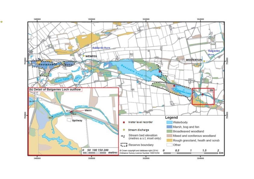
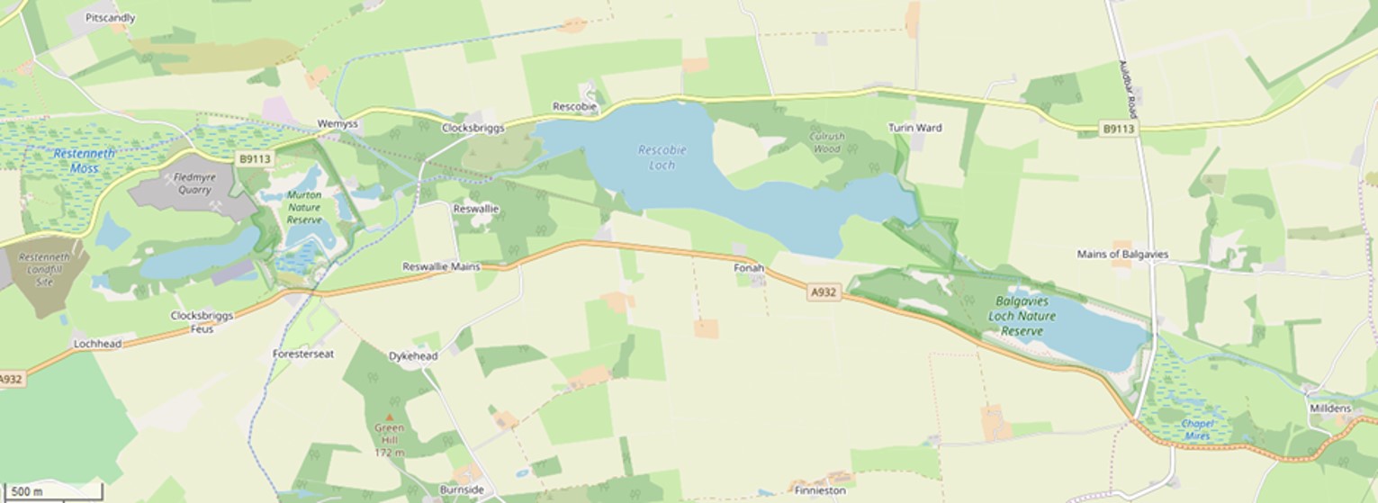
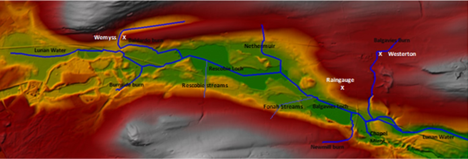
Upper Lunan Water showing core wetland features, hydraulic structures downstream of Balgavies Loch (insert) and monitoring points.
A workshop with Centre for Ecology and Hydrology was held in 2016 to conceptualise and compare water ecosystem services in these catchments. Seven main elements of Ecosystem Services provision affected by sediment and water management were identified as common to the two catchments. These included:
- The ecological response of changing water levels in wetlands associated with the lochs
- Potential for management of water quality and pollutant loading into conservation wetlands
- The impact of flushing regimes, as determined by hydraulic controls on aquatic ecology
- Water governance challenges at catchment scale
In the Lunan water catchment, local stakeholder interviews were carried out in the summer of 2014 with 16 stakeholders. These interviews explored views on water issues in the catchment, causes and potential solutions as well as the potential to establish schemes to pay for water benefits in the catchment.Lunan Water Catchment Management Group was formed, with Angus Council chairing, to help oversee the project and act as a forum for catchment management issues. This has met regularly since July 2016 with participants from Angus Council, SEPA, SNH, Scottish Wildlife Trust, Dundee University, NFUS, and Esk RIvers and Fisheries Trust, and James Hutton Institute. Minutes and reports to these meetings are available here.
Loch Leven was the subject of the first Catchment Management Group in Scotland, and a recent CEH report summarised the historic and current water management issues in the catchment. The report from the Nov 2019 meeting is available here.
Three potential schemes have emerged for Payments for Ecosystem Services in these two catchments.
- Water for all (Lunan Water)
- Fishing for farmers/less erosion-less dredging (Lunan Water)
- Flushing for water quality (Loch Leven)
The Water for all scheme on the Lunan Water has focused on hydraulic management of a weir downstream of Balgavies Loch. We proposed that management based on a hydraulic model and possible upgrading of the hydraulic structures might generate benefits for flood risk management, irrigation abstraction/low flows and sensitive wetland ecology. A remotely operated titing weir, releasing surplus storm water from the common lade to the Lunan Water, for example, might alleviate upstream flooding, which was a concern to local residents and Angus Council.


The aim was to develop proposals for a locally managed scheme which be financially justified by the benefits accruing to local stakeholders.
A postal and online survey was implemented in the Lunan Water catchment area in 2017 to measure quantitatively the support for the “Water for all” project. These results are complemented by qualitative interviews. More information here.
The water levels and discharges in the Upper Lunan Water are recorded and available in realtime for several stations (see map here). These data have helped us design and calibrate a modelling tool, to simulate and forecast loch water levels and channel flows. Impacts of management of both existing and potential hydraulic structures, and of dredging of key channel reaches, can be considered.
Input data are rainfall, evapotranspiration, catchment areas and channel/floodplain hydraulic data.A hydrological model predicts stream and groundwater inflows to the Lunan Water and its wetlands.The loch and wetland water levels and flows in the channels downstream of Balgavies Loch are simulated using the hydraulic modelling package, HECRAS.
RESULTS

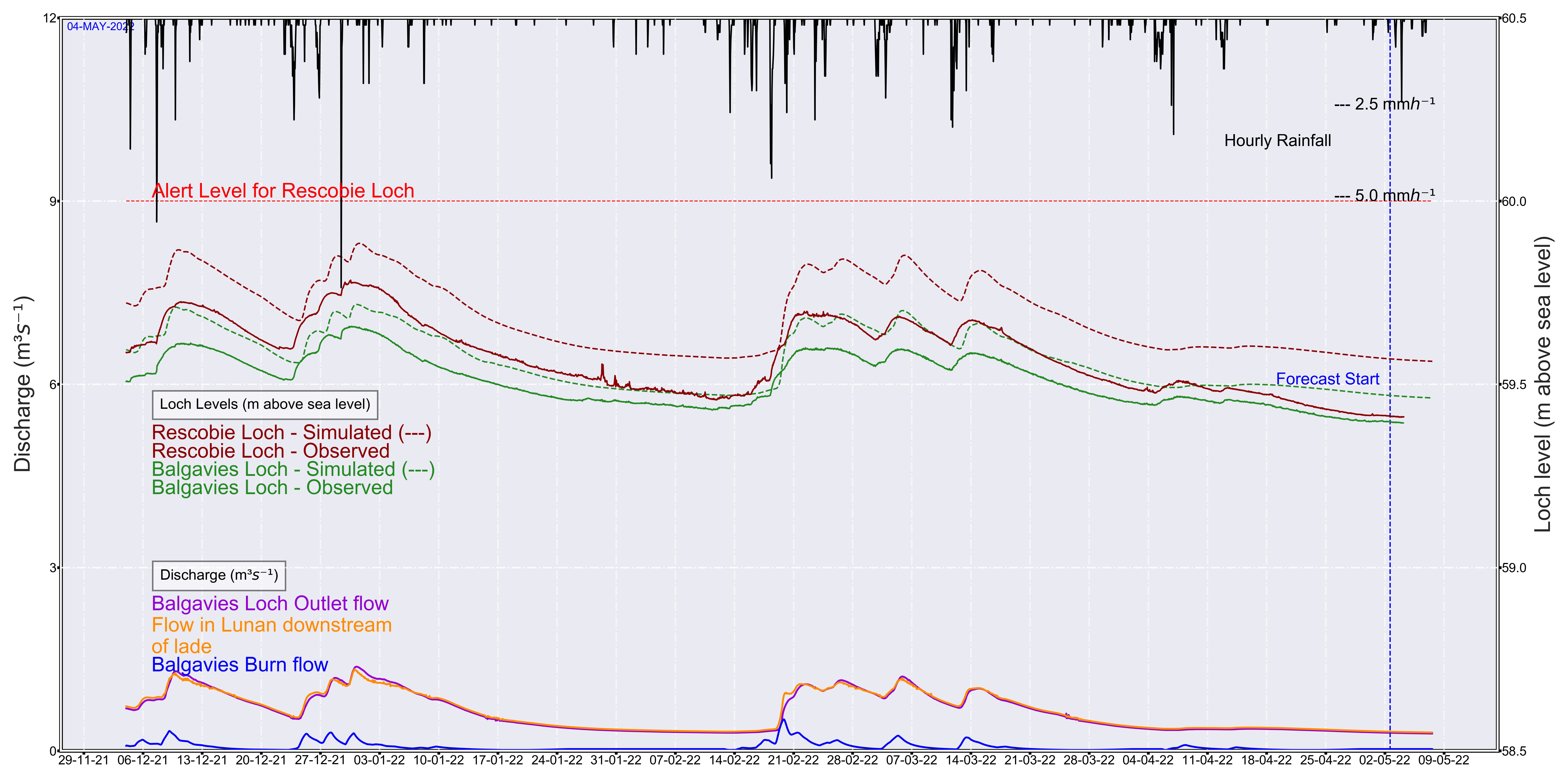
An example of model simulation of PAST WATER LEVELS AND FLOWS compared with observations of Balgavies Loch levels is shown below. These simulations update daily to this webpage. Such information could, for example, help alert local water managers to the presence of logjams in the main channel of the Lunan Water, causing much higher water levels than simulated (see January 2020 in the figure below).
Using Met Office Forecast data we are also able to FORECAST WATER LEVELS AND FLOWS, and an example of such simulations is shown below. These simulations also update daily. Such forecasts could help with identifying a need to alter the opening on the gates controlling the existing weir, or, in the case of an upgrade of hydraulic structures, to adaptive management by remote control.This would be especially relevant if Rescobie Loch levels were forecast to exceed the Alert level (red dotted line) when road flooding would be likely.
A presentation proposing changes in water management was made at Scotland’s Biennial Land Use and the Environment Conference XII (28-29 November 2018): Rewarding the Delivery of Public Goods: How to Achieve this in Practice? https://www.sruc.ac.uk/landuseconf
Social science research has shown conflicting levels of support between farmers and residents for engineered management of the catchment. We articulate these differences along four interlinked themes: local socio-historical norms; understandings of scientific knowledge and practice; the perception of individual rights and responsibilities in relation to water ; and concepts of ‘nature’ - particularly concerning interventions in ‘natural’ systems.
A report, making use of the modelling framwork to explore further scenarios of management and proposing actions on the upper Lunan Water has now been completed, and is available here. This has led to a concept note for reinstatement of a blocked spillway, which will help relieve pollution pressure on Chapel Mires wetlands. This has been discussed with and agreed by, the Lunan Catchment Management Group and riparian owners on 31 March 2021. The way is now open for exploration of funding sources to deliver this re-instatement.
A publication is also available below:
Vinten, A.J.A., Kuhfuss, L., Shortall, O., Stockan, J., Ibiyemi, A., Pohle, I., Gabriel, M., Gunn, I., & May, L. 2019. Water for all: towards an integrated approach to wetland conservation and flood risk reduction in a lowland catchment in Scotland. Journal of Environmental Management, 246:881-896.
http://nora.nerc.ac.uk/id/eprint/524193/
Student projects by Remi Trenkmann (hydraulic modelling) and Marjorie Gabriel (wetland ecology/geochemistry survey), vistiting students from ENGEES, Strasborg, France are described here.
This PES idea focused on achieving agreement between fishing/wetland conservation interests and riparian farmers for erosion control measures. For example:
- better erosion control could be made a condition of fee payment from riparian recreational fishing interests to riparian farmers who own Rescobie Loch (fishing for farmers)
- dredging licence agreements could be tied to upstream erosion and sediment mitigation (less erosion-les dredging).
The hydraulic modelling undertaken through the Water for all scheme has shown that dredging will benefit the delivery of reduction in flood risk, for example by lowering the bed level in the common lade downstream of Balgavies Loch.

In November 2016, Andy was invited to speak at the AGM of the Rescobie Loch Development Association and riparian owners. His report noted th e need for better management of Canadian pondweed harvested from the Loch to enhance fishing, which could provide a project for the "fishing for farmers" PESLES project. However the group felt it was impractical to link payments to local actions, as there were existing regulatory and voluntary routes for achieving better erosion control.
The linkage between erosion control and finance was therefore pursued by promoting un-funded regulatory and voluntary measures (eg adopting erosion control plans drawn up for selected farms) prior to promoting application for funded measures under the Scottish Government AECS scheme. This has focussed on farms draining into Fonah Bog, an SSSI on the south western margin of Balgavies Loch.

Scottish Natural Heritage, promoting an interest in protecting local wetland habitats from the impact of sediment and nutrients, have supported an ongoing programme of diffuse pollution mitigation plans for specific farms draining into the protected wetlands in the upper catchment, including Restenneth Moss, Fonah Bog, and Chapel Mires. Diffuse pollution plans have been drawn up by Lockett Agri-Environmental for farms in the upper catchment.The diffuse pollution plans were necessary pre-requisites to developing plans and funding proposals for Rural Sustainable Drainage Systems (rSUDS) measures at specific sites, on the basis that sediment and nutrients runoff should be mitigated at source as much as possible, before implementation of edge-of-field or downstream retention measures.

The case for dredging the common lade on the Lunan Water downstream of Balgavies Loch was made at the March 2018 Lunan Catchment Management group meeting, with a subsequent site visit with SEPA. However, it was felt that more emphasis on ways of mitigating input of sediment should be made, and it was considered unlikely that a lcence for dredging application would be successful. A short stretch upstream of a bridge could perhaps be considered, and vegetation removal could be pursued without licence requirements.
What lessons on the funding and implementation of the sediment mitigation methods described above can be drawn from the processes in the Lunan Water catchment?
- Farmers were receptive to carrying out diffuse pollution audits of activities
- During the early part of the Lunan Water Diffuse Pollution project (2006-2011), Agri-Environment funding was not particularly well aligned with water quality goals, but in some cases, farmers were ready to fund innovative solutions (ed sediment traps and ponds) from their own resources. However, this meant the design element was somewhat lacking. This issue has to some extent been resolved by the publication of the rural SUDS guide.
- Farmers in the catchment were sometimes ready to host experimental and demonstration innovative solutions (eg sediment fences), during the research phase of the project (2011-2016), but there was also some resistance. One farmer wanted a signed agreement concerning activities and re-instatement costs before agreeing to host a pilot sediment retention pond.
- At the Lunan catchment science group meeting in June 2013 there was a feeling from farmers that not many people in the lower catchment are involved in funded environmental schemes.The issue is that most measures involve removing land from production, and the land there is simply too profitable for that to be economic. It’s a different story in the upper catchment.
- Funding is an issue for some. Rates for agri-environment use of land haven’t changed much over the last ~20 years, whilst the return off the land has increased. So whilst it was once clearly economical in places to adopt agri-envionment measures, now it may not be so clear cut.
- Discussions between landusers in the current phase of the project (2016-present) have highlighted the question of responsibility for receiving /treating and managing sediment from upstream neighbours. It is a legal responsibility to receive the upstream neighbour’s water, but what about their sediment? At several points, the Fonah Bog (part of the SWT run Balgavies Loch SSSI) receives sediment from upstream neighbours. This sediment also blocks culverts under the road between Fonah bog and upstream neighbours, leading to requirement for maintenance of the culverts and the immediate area downstream for prevention of flood risk, on SWT land.
- It is difficult to agree setting aside adequate ground for sediment traps or ponds funded by AECS to deliver the rural SUDS guideline of 0.25% of the catchment area. It has been easier to agree funded and area set-aside for swales and buffer strips, and this probably reflects more generous funding and ease of implementation within existing management of fields.
- The co-ordinated input of Environmental consultants (SRUC (in 2006-2011) Lockett-Environmental, Moir Environmental (in 2016-present)), Agencies (SEPA and SNH) and Research scientists (JHI) has helped facilitate the progress in implementation of sediment mitigation measures.
- At a very local level, there has been increased dialogue between upstream producers of sediment and downstream receivers. This occurs both on a 1:1 basis (eg for Fonah Bog) and through standing committees, such as the Balgavies Loch committee (chaired by SWT), Rescobie Loch Development Association and Community Councils. JHI researchers have been regularly invited to provide updates at some of these local bodies (such as Rescobie Loch Development Association).
- The AECS funding for Water Quality measures have achieved some uptake for grant applications and implementation has begun in the upper Lunan catchment. However, the overall impact of measures currently implemented, compared to the level of mitigation required, is quite small.
Andy presented a poster summarising this work at the 100th meeting of the Scottish Freshwater Group at Stirling University, April 19-20, 2018. See all 2018 presentations here.
A report on the uptake of rural SUDS in the catchment is available here.
3. Flushing for water quality
Climate change effects can produce unexpectedly large algal blooms at a time when nutrient inputs to a water body appear to have remained stable. Questions are now being asked about whether current loch and reservoir management practices, many of which have been in place for decades, are still fit for purpose under a changing climate and whether changes could be made to help mitigate climate change impacts in the future. By applying a scenario based modelling approach to Loch Leven, a well monitored loch in the Scottish lowlands, we have undertaken an initial exploration of the extent to which changes in the rate at which water is discharged from the outflow could help to reduce the likelihood of algal blooms, especially of cyanobacteria, during the summer months.
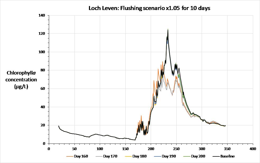
The results of this study (full report here) suggest that small changes made to the flushing rate of lochs and reservoirs have the potential to reduce the water retention time sufficiently to reduce algal blooms by as much as 40%. Increasing flushing rates by increasing inflow volumes is difficult to achieve, due to the extra water required, but reducing water retention time by increasing outflow volumes would be relatively easy to achieve in systems where the outflow from the waterbody can be regulated by dams or sluice gates.
The effect on total chlorophyll a of 5% increase in discharge from the Loch Leven outflow weir for 10 days from the start dates shown
The benefits of achieving lower cyanobacteria levels in Scottish lochs and reservoirs would be to increase in their recreational and amenity value and reduction water treatment costs to remove algal toxins and substances that cause taste and odour problems in water supplies. It has been estimated that improving the water quality status of Scottish lochs adds about £1,500 per hectare per year to their value (Glenk et al., 2011). From this it can be estimated that the value of a single loch, such as Loch Leven, in terms of its recreational and amenity value would increase by about £2m if problems caused by cyanobacterial blooms were reduced. For lakes that are used for water supply, the costs of water treatment to remove algal toxins and decomposition products were estimated to be about £21.4m per year for the UK by Pretty et al. (2003). This equates to a present day value of about £30m, a cost that would be reduced significantly if algal blooms were less common.
Decisions on how to implement such changes would need to take into account a wide range of, often site specific, factors that could be affected by changes in water retention time and levels of discharges from the outflow. These include maintaining environmental flows downstream of the waterbody, ensuring that water level changes do not have an adverse effect on the ecology of the waterbody, and the need to maintain levels of abstraction for water supply purposes or of flows to support power generation. So, any decisions to make such changes would need to be taken by all of those involved in the governance of the waterbody, including environmental regulators, conservation bodies and water users. However, the results outlined above suggest that it may be beneficial to explore this potential approach to reducing algal blooms in more detail.
A further step has been to demonstrate the potential for using the combined hydrological/hydraulic modelling approach used on the Lunan Water, for managing the sluice gates on Loch Leven to deliver an increased flushing rate in early summer. A report showing how sluice gate management could be modified has been prepared.
- In the July 2016 workshop in Forfar, Andy Vinten discussed the impact of a weir downstream of Balgavies Loch on water levels at high and low flows.
- In the October 2016 meeting, Andy discussed the potential impact of introducing a tilting weir into this area to increase high flow capacity and manage low flows for downstream users. We also discussed a new Scottish Government funded project to facilitate uptake of funded and unfunded measures to mitigate soil erosion and sedimentation in the catchment.
- In the January 2017 Catchment group meeting we discussed the need to set up a smaller steering group to take forward consent proposals. It was agreed that there should be two groups – one taking forward the tilting weirs project and the other looking at the wider catchment issues and social issues affecting the project.Click here for tilting weir proposal update.
- In the April 2017 Catchment group meeting we discussed the consenting progress and agreed that a sub-group would draft a consent application for comments and consideration of the riparian owners and others with a significant interest. Laure Kuhfuss discussed plans for the social science survey which will explore the interaction between willingness to pay for water management in the catchment and method of governance. In addition Andy Vinten mentioned that a student project this summer will explore the extent of mixing of the waters in Chapel Mires with river water.
- In the October 2017 Catchment group meeting a report was tabled which summarised the case for introduction of a tilting weir and progress in social science work surveying attitudes to this intervention. This report linked to more detailed reports on (a) preliminary modelling of hydraulics using HECRAS (b) An aquatic plants survey of chapel mires done in Sept 2017. The report, prepared by Centre for Ecology and Hydrology is available here. (c) socio-economic survey of attitudes to the proposed project. Andy VInten reported on the response to the report submitted to the Balgavies Loch Committee which met in July 2017 and riparian owners to proposals.
During winter 2017/8 the project has focused on developing a hydraulic model, using HECRAS, of the water courses downtream of Balgavies Loch, so that the likely impact of changing lateral structures on the mill lade (eg a tilting weir) could be assessed.
- This report was tabled at the 6th Lunan Catchment Management Group on 22nd March 2018 for feedback from stakeholders. A key finding was that dredging the lade would be beneficial, prior to any enhancement of hydraulic management of the site. Installation of a lateral tilting weir to improve release of water from the mill lade could provide a benefit to the Chapel Mires ecology by aiding diversion of nutrient-rich waters away from sensitive areas.
- Part of this work involved developing a real time and forecasting model of water levels in Balgavies Loch which could be used by stakeholders as part of water management decision making.
- In addition, summaries of the social science survey work and interviews have been prepared and tabled at this meeting. This work has identified the "governance gaps" that existing with respect to water management and the need to explore methods of resolution over a range of different catchments and issues.
- Draft minutes of the 6th Lunan Catchment Group meeting are available here.
- Agreement was reached, in principal, that removal of debris and vegetation from the mill lade would be beneficial,
- A registration application for dredging the 10m of lade upstream of the existing cattle bridge should also be considered.
The 7th Lunan Catchment Management Group was held on 22 March 2019.
This included reports as follows:
- Water for all project (paper A)
- Design and implementation of rural SUDS in the upper catchment (paper B)
- Trends in water quality in upper Lunan (paper C)
Important points arising included:
- Re dredging and vegetation removal in common lade.Angus Council (AC) does not have the powers to implement dredging of the Common Lade/Mill Lade d/s of Bagavies Loch. Further to the previous meeting, a site visit by Tony Allan (SEPA) took place, and it would be likely to be difficult to get a licence to dredge the lade, apart from the first 10m upstream of the bridge over the lade upstream of the confluence of Balgavies Burn. SEPA’s view is that catchment measures are needed to control sediment. For more extensive dredging, a licence would be needed.However, vegetation removal was seen as within the potential scope of AC activity, and a contractor which specialises in aquatic vegetation removal has been identified.
- Soil conservation plans.SNH noted that these had been completed on several farms in the upper Lunan Water, and potential funding existed for a further farm in the coming financial year.Some implementation of SUDS had started (see paper B).
- Water scarcity risk has continued to increase across most of Scotland. On the Lunan Water. river, loch and groundwater levels were low for the time of year and soil moisture deficits were high at an important point of the year for the agricultural sector.
The 8th Lunan Catchment Management Group meeting was held on 25th November 2019.
AV reported on progress with hydraulic modelling in the catchment, facilitated by a 6 month internship by a student from ENGEES, Strasbourg (see Student projects, below). Results of this work are showing that operation of the existing weir structures do influence high flow water levels, and improved management of existing gates, and/or greater capacity of high flow structures at Milldens weir would help reduce the risk of flooding in the area of Resocobie Loch. It was agreed that a wider discussion about hydraulic management with local stakeholders and water users should be initiated in spring 2020.
SEPA reported that plans for the Lunan Priority Catchment implementation were on track with likely starting date later in 2020.
A report was tabled on progress in implementation of sediment controls in the upper catchment and a field visit took place in the afternoon. The wet autumn had led to several burst field drains which had hampered the operation of some of the new SUDS installations.
The 9th Lunan Catchment Management Group meeting was held online on 31 March 2021.
A report and concept note proposing restoration of a blocked spillway on the Lunan was tabled and accepted in principle. Problems with implementation of sediment controls on inputs into Fonah Bog, and potential solutions were discussed.
Remi Trenkmann, a student at ENGEES, Strasbourg, completed a 6 month internship at James Hutton Institute. It was a required part of his Masters degree in Water and Environmental engineering, at the Graduate school of Environmental Engineering and Water Resources Management. His project developed a non-steady state model of hydraulic management options for the upper Lunan Water, supplementing work already completed on a steady state hydraulic model.
Summary of a key result is available - introducing a 4m wide tilting weir that opened at loch water levels >59.6m (or a fixed weir of this width) would provide 10cm reduction in upstream loch water levels during large storm events. This would only happen if the siting were below the confluence of the Balgavies Burn and the Lunan Water. It would not be effective for the very large event (Storm Frank).
One of possible benefits of a tilting weir is that it could be used to manage the inputs of water into the Chapel Mires wetlands downstream of Balgavies Loch. In summer 2017, a project by Marjorie Gabriel, a visiting student from ENGEES, Strasbourg, France, invetigated the mixing of water from the river with Chapel Mires sources, and sought to identify the sources of water in Chapel Mires. This work is summarised here.
A major part of the 2017 work in Chapel Mires consisted of drafting a National Vegetation Classification map of the area. This shows the presence of nutrient-loving wetland species such as Phalaris arundinacea (canary grass) encroaching into Chapel Mires in the areas closest to the river, while the areas further away are characterised by a more ologotrophic, sedge-rich vegetation. This also matches up with observations of lower contributions from river water to the composition of the water in the wetland, further away from the river.
This work has been supplemented by further sampling and analysis in the later part of 2017 and is now written up as a report for Scottish Government entitled:
Could managing water levels of Lunan Water at the outlet to Balgavies Loch help conserve Chapel Mires from eutrophication and loss of biodiversity?


Canary grass in area of Chapel Mires close to river Sedge-rich area containing bogbean,cowbane,tufted loosestrife etc
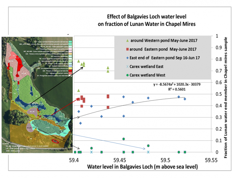
Map of National Vegetation Classification of associations of plants in Chapel Mires and estimates of river water contribution to composition of Chapel Mires waters.
Both under current and dredged channel conditions, the installation and active management of the weir provided opportunity for diversion of seasonal nutrient rich water from the upstream Lake away from a downstream floodplain wetland, Chapel Mires. A rapid assessment of the ecology of Chapel Mires and mixing analysis of the waters in these wetlands with the Lunan Water supported this view. Carrying out dredging of the channel reduced the current observed probability of upstream flooding from 3% to 1% and the proposed tilting weir would help to maintain these dredging benefits.
Socio-economic survey of attitudes to Water for all project
Following completion of ethical approvals, both by Scottish Government and internal committee, an online and postal socio-economic survey is undergoing. This aims at: (a) measuring and discussing whether the benefits are perceived to be worth the costs of the project by local stakeholders and residents; (b) proposing a governance strategy that would enable the sustainability of this scheme in the long term.
A survey was implemented in the Lunan Water catchment area in July and August 2017 to measure quantitatively the support to the “water for all” project, which proposes the installation of a tilting weir and a flow restrictor at the outskirt of Balgavies loch for water management. The preliminary results presented herein. In parallel, to complement the online survey, we interviewed stakeholders and residents in person. A summary of these interviews is available here.
Colleagues at Centre for Ecology and Hydrology contributed to the summary report for the 5th Lunan Catchment Management Group with a review of the aquatic ecology of the Lunan Water system. This focused on a survey of the aquatic plants in Chapel Mires and consideration of impacts of water level change in Balgavies Loch. The detailed report is available here.
The report concluded that (a) there is likely to be little or no negative impact to the qualifying interests from the introduction of a tilting weir, and any significant reduction in nutrients to the systems should be considered as potentially beneficial; (b) the available information suggests that fluctuations in water level of the magnitude proposed for Balgavies Loch are likely to have relatively minor impacts on aquatic plant communities.
A workshop with Centre for Ecology and Hydrology was held in 2016 to conceptualise and compare water ecosystem services in Lunan Water and Loch Leven catchments. We compared how changes in sediment and water management might influence ecosystem service delivery in the two catchments. Through discussing these ideas we were able to identify seven main elements of Ecosystem Services Provision that were affected by sediment and water management and could be compared between the two catchments. These were:
1. The ecological response of changing water levels in wetlands associated with the lochs.
For example, on the upper Lunan Water catchment there are several wetlands (Restenneth Moss, Clocksbriggs, Fonah Bog and Chapel Mires), which may be sensitive to changing water level management.
At Loch Leven there are several wetlands managed by the RSPB that will also be sensitive to changing water levels.
2.Potential for management of water quality and pollutant loading into wetlands
For example, the loading of nutrients to these wetlands may vary with the time of year, as this influences for example release from loch sediment, with flow levels and with water level management. Andy Vinten gave some clear examples of how intervention to manage water levels could help reduce nutrient loads to Chapel Mires, on the Lunan Water.
3. The impact of flushing regimes, as determined by Loch exit gate levels, on aquatic ecology.
For example, at Loch Leven, the sluice gates that control the outflow are regulated according to a Royal Charter that aims to deliver sufficient water downstream to meet industrial requirements. However, there is potential to manage the flushing rate at the site in such a way that it allows nutrients that are released by from the sediments to be flushed out of the loch, rather than encouraging them to re-circulate.
On the Lunan Water such an approach could help to return Lochs Rescobie and Balgavies, which have significant internal loads of phosphorus, to good ecological status over a number of years. This is more feasible, without endangering river ecological status, now that the river soluble P status has returned to “Good”.
4. The management of fish passage and influence on ecology of fish
At Loch Leven, the outflow is currently impassable to fish because of the sluice gates that were installed in the mid-1850s. There are concerns that re-instating fish passage into the outflow would allow parasites from infested trout populations downstream to enter the loch, to the detriment of the local recreational fishery. Improving fish passage may also lead to invasion by less desirable species, such as roach, with potentially damaging effects on water quality.
Such issues do not occur on the upper Lunan Water at present, because of barriers to migration, but might be an issue if water level management through tilting weirs took place.
5. Opportunities for ecotourism and attitudes
The local wetland ecology and its associated wildlife supports a significant tourist economy in the Loch Leven catchment. This is in contrast to the Lunan Water catchment where access to the reserve to view birds, especially the nesting Osprey, is seen by reserve managers as potentially damaging to aspects of the ecology, such as wetland vegetation.
6. Governance approaches to water level management.
There is strong local input from riparian owners into water level management in the Lunan Water, but this is done on quite an informal basis. In contrast, in the Loch Leven catchment, governance of water levels is controlled by a Royal Charter and involves a wide range of stakeholders. Whilst this means, in theory, that many stakeholder interests are represented, it also makes decision making and management of change very slow and cumbersome. The original aim of installing flow regulation on the outflow from the loch was to provide a constant supply of water to downstream industry. A strong bias towards managing the water level of Loch Leven to meet the needs of downstream users remains to this day. There are proposals to electrify the Loch Leven sluice gates over the next couple of years, which may lead to more integrated management. Some lessons learned at Loch Leven may be applicable to the management of water levels in the Lunan Water via remotely controlled weirs.
7. Opportunities for hydro schemes
The existence of exit structures from lochs in the two catchments provide potential opportunities for hydro-electric generation schemes. There are existing hydro-electric generation schemes on the River Leven downstream of the Leven sluices.
Subsequent CEH involvement in the project has included:
- Development of a model of water quality in Balgavies Loch, as an input into a model of mixing of river water and Chapel Mires water. This report is available here:
- Survey of aquatic plants in the Chapel Mires and in Balgavies/Rescobie Lochs. REVIEW OF THE AQUATIC ECOLOGY OF THE LUNAN WATER SYSTEM: RESAS PESLES PROJECT – CONTRIBUTION TO REPORT D3a, OCTOBER 2017 Iain Gunn, Mattie O’Hare and Justyna Olszewska (CEH, Edinburgh)
- A note on the impact of including internal and septic sources of P on the cost-effectiveness of P mitigation for the catchment, by Andy Vinten and Bryan Spears.
- A report and briefing note on the impact of flushing rate on algal blooms in Loch Leven
Presentations
2021-22
A report, making use of the modelling framework to explore further scenarios of management and proposing actions on the upper Lunan Water has now been completed, and is available here.
This has led to a concept note for reinstatement of a blocked spillway, which will help relieve pollution pressure on Chapel Mires wetlands. This has been discussed with and agreed by, the Lunan Catchment Management Group and riparian owners on 31 March 2021.
A note for stakeholders summarizing the findings of the PESLEC project (Lessons from the study on Payments for Ecosystem Services) was prepared as available here.
A closing online workshop for the PESLES project was held on 10th December 2021. This was attended by more than 20 participants. The flyer for the workshop is here. The report from the workshop is here.
2020
Andy Vinten presented the work at an internal JHI Seminar in June 2020.
- Andy Vinten presented a poster at the 100th meeting of the Scottish Freshwater Group at Stirling University, April 19-20, 2018.
- Andy Vinten presented a paper and oral presentation at the 3rd Regional IWA Diffuse Pollution Conference in Chiang Mai, Thailand Nov 20-22 November.
- Water for all: analysis of a proposed novel approach to wetland conservation and flood risk reduction in the Lunan Water, Scotland, using a tilting weir.
- A.Vinten, L.Kuhfuss, O.Shortall, A. Ibiyemi, I.Pohle, S.Addy, M.Gabriel, I.Gunn, P.McPhailand J.Corrigan
Andy VInten made a platform presentation at Scotland’s Biennial Land Use and the Environment Conference XII (28-29 November 2018): Rewarding the Delivery of Public Goods: How to Achieve this in Practice?
The presentation was entitled: How can we enhance the role of local land and water users indelivering catchment scale water ecosystem services ? by Andy Vinten, Orla Shortall and Laure Kuhfuss.
The objective of the Scottish Government funded PESLES project (Payments for Ecosystem Services: Lessons) is to build understanding of what incentives or arrangements could be considered appropriate and effective in enabling and encouraging stakeholders to adopt measures that will improve water management and diffuse pollution control.
This is being pursued with stakeholders in the Lunan Water catchment, by developing and promoting proposals for (a) innovative hydraulic management of water levels and dredging (b) implementation of rural SUDS, while also assessing willingness to pay and local attitudes to proposals through survey, interviews and a catchment management group.
Uncertainty about technical performance, gaps in governance and long term management plans, and single issue vs multiple issue perspectives, are among the issues encountered. It may be that internal drainage boards, or other catchment-wide finance and governance mechanisms, would help achieve progress.
Ina Pohle presented a model to forecast water levels and flows from Balgavies Loch in real-time at a German Hydrological Society Conference in March 2018. The English version of this is available here. It was presented at the European Geophysical Society meeting in April 2018.
- Andy presented the project to a delegation from Shandong South-to-North Water Diversion Administration Bureau, China, visiting JHI Dundee on 22nd November 2016
- In December 2016, two meetings with riparian farmers were held to discuss potential sites for sediment retention bunds/wetlands in fields adjacent to Fonah Bog.
- Andy also gave an internal seminar on 15 December 2016 entitled:
He made the case for installation of a tilting weir downstream of Balgavies Loch based on:
-

Flood risk. Using simulations over the 2011-2016 period, we estimate managed use of such a facility would decrease the frequency with which the water level of Rescobie Loch is above 60m (which is 1m below the road at Rescobie Loch Boathouse) from 6% of the time to 2% of the time.
- Wetland biodiversity protection. There are wetland habitats, for example at Chapel mires, which contain locally rare or scarce species such as Cicuta virosa (Cowbane), Lysimachia thyrsiflora (Tufted Loosestrife) and Menyanthes trifoliate (Bogbean). These habitats could be affected by water level changes in Balgavies Loch and water management downstream. The effect might be positive because the loch outflow in late summer is nutrient (phosphorus) rich and some of this flow into these wetlands could be restricted by a tilting weir. There may also be negative impacts if water levels are maintained at too low a level ( for example at <58.9m at the spillway into Chapel Mires), at critical times for the wetland ecology.
- Mitigation of low flows. The ecological status of the Lunan Water has been downgraded partly because of the impact of water abstraction at low flows. Near the mouth of the Lunan Water, at Kirkton Mill, Inverkeilor, flows low enough to lead to potential irrigation restrictions by SEPA, occur 3-4 years in 10, during July and August. Restrictions could occur 10-20 days per month in these years.
The risk of restrictions occurring would be reduced by around 50% by an additional flow of 30 L/s provided by lowering the level of a tilting weir at Balgavies outlet in these months. We have previously estimated that the potential economic benefits to irrigators of mitigating such restrictions at low flows amounts to £30k per year over a 10 year period.
- These ideas were presented to the 3rd Lunan Catchment Group meeting on 25 January 2017 at the County Buildings, Forfar, Angus.
- We prepared a poster " Participatory research to find solutions to water management issues in the Lunan catchment" by Orla Shortall, Laure Kuhfuss and Andy VInten, for a workshop on catchment-scale farmer cooperation and environmental benefits being held at Glensaugh on 13 September 2017. This is available here.
- A brief presentation of progress in the project was made at the Theme 1 meeting on 2nd October and again at the James Hutton Institute research symposium on 22 November 2017.
- A progress report was presented at the 5th Catchment Group meeting on 24th October 2017.
- Andy attended the Friockheim Community Council on 6 Dec 2017 to update them on the water for all project, at their invitation.
- Andy also attended the Rescobie Loch Development Association AGM on 15 Feb 2018, and gave an update on progress on the PESLES project. Minutes available here.
- Ina Pohle presented a model to forecast water levels and flows from Balgavies Loch in real-time at a German Hydrological Society Conference in March 2018. The English version of this is available here. It was presented at the European Geophysical Society meeting in April 2018.
For more information about this ongoing research contact: Andy Vinten, Laure Kuhfuss or Orla Shortall
 SEFARI is the collective of six Scottish world-leading Research Institutes working across the spectrum of environment, land, food, agriculture and communities – all topics which affect how we live our lives, in Scotland and beyond.