Delineating critical zones of riparian processes and setting effective buffer areas using spatial data
Introduction
The riparian zone occupies the critical interface between land and watercourses where processes have great potential to influence stream and river biogeochemical and ecological conditions and is a key management location. Riparian influences on water quality may arise from:
- filtering and buffering capacities pollutant transfers from the land activities to water, and
- wider riparian functions that increase the resilience of the riparian-channel system to local or upstream pressures, such as coupling of terrestrial and aquatic ecosystems, or shading.
We make a distinction between the riparian zone and a buffer zone. The former implies a zone with a gradient of hydrological, habitat and geomorphic change from land to channel, the latter implies a management zone designed to separate potentially negative pressures of land activities from the aquatic ecosystem. There has been considerable debate over minimum riparian buffer widths for protection of stream ecosystems (e.g. Sweeney & Newbold, 2014). Hansen et al. (2015) found that studies collectively supported needs for variable buffer widths to protect watercourses depending on circumstances but the available body of riparian literature insufficiently or inconsistently reported the landscape contexts necessary to explain inter- and intra- study variability in outcomes. Hence, riparian structure and functions, both current and potential and informed strongly by landscape setting, are required to be considered alongside the environmental objectives (such as maintaining, or improving water quality and other multiple benefits).
 [1]
[1]
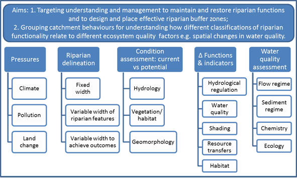
Figure 1. Schematic of how assessment of presures, riparian indicators of function and relationships with water quality parameters contributes to the two aims of the current review.
Figure 1 shows twofold aims that guide this current review. The first concerns the spatial targeting of understanding and management to maintain and restore riparian functions, to design and place effective riparian buffer zones. The second aim is to give catchment scientists improved methods for characterising important catchment riparian functions that relate to water quality to improve evidence on the connection between riparian condition and water quality to facilitate better management. The delineation of riparian zones is a key requirement of riparian management, forming a basis for the understanding the optimal zones to maintain or restore critical riparian functions. Yet delineation remains challenging and the literature suggests a variety of methods that have not been reviewed previously. This review examines:
- Key riparian processes;
- How spatial data is contributing to process understanding and how such data are being pooled;
- How riparian areas are delineated from simple fixed width methods to variable width methods considering processes, catchment pressures and desired outcomes.
Processes and indicators relating to riparian functions
There are numerous schemes for assessment of riparian functions and key functions themselves concentrated on by regulatory actions. An example of a full description of a long-time implemented assessment scheme is given by Swanson et al. (2017) for the riparian Proper Functioning Condition (PFC) assessment that is integrated with, and assessed against, water quality monitoring in Nevada, U.S. The PFC assessment is based on scoring indicators of vegetation, hydrology and geomorphology against potential natural condition with regard to provision of functions: dissipation of stream energy, capturing sediment, increasing water recharge, rooting and bank stability, maintaining channel characteristics. Such core functions are common to many riparian assessment studies. The structure of section 2 here expands on this grouping according to: hydrological connectivity, water quality, shading and temperature regulation, resource transfers and terrestrial habitat. We describe indicators of the functions prior to assessing how these functions and their data are currently integrated into riparian delineation in Section 3
The dominant process groups are briefly presented below and key studies are indicated in Table 1
- Extreme flows and hydrological connectivity
- Surface roughness - the effects of riparian vegetation and buffer surface form on runoff hydrology, trapping eroded material from upslope sources and the protection of erosion within the buffer itself.
- Groundwater-surface water interactions for water table and stream flow buffering - the hydrological regime (fluxes, water level, duration, frequency, timing) is key to buffer functions and varies across scales and is damped by the presence of riparian wetlands
- Maintaining water quality - Buffers can act on three key pollutant source pathways, namely: surface runoff, stream bank erosion and shallow and deeper groundwater pathways.
- Surface runoff trapping and minimising bank erosion - The trapping efficiency per width is dependant on vegetation type and buffers intended mainly for this trapping are often called filter strips.
- Groundwater-surface water interactions for water quality - the upslope-riparian-channel continuum’s hydrological regime constitute an important interaction determining water quality in adjacent streams, with controls of water residence time factors (riparian slope, soil texture and hydraulic conductivity) with water table depth and soil organic carbon
- Shading and temperature regulation - water temperature is a key aquatic habitat variable and riparian trees reduce heating of in-channel water by shading solar radiation and cooling by evapotranspiration of shallow groundwater and soil water.
- Resource transfers – two-way resource exchanges occur e.g. aquatic insects provide food for terrestrial species and aquatic ecosystems receive multiple resources such as DOC, leaf litter, woody material and food from invertebrates that benefit a range of aquatic trophic levels.
- Terrestrial habitat – water table variation affects riparian plant communities through water table as well as nutrient and acidity controls and local topographic variation and upwelling groundwaters resulted in ‘hot-spots’ of high plant species richness.
 [2]
[2]
Current methods to delineate riparian areas
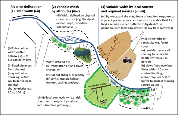
This section is structured according to different methods of representing riparian processes spatially (Figure 2) considering simple fixed to more complex variable width methods.
Figure 2. Schematic of different riparian situations to illustrate the three main classes of riparian delineation considered here: fixed width, variable width by attributes and variable width by local context and required outcomes, together with eight submodels.
Fixed width approaches
- According to policy and funding schemes - Buffer widths can be prescribed by policy with national-level or goal-specific widths. These may vary with stream-river size classes but are often simplified for administrative ease.
- Other fixed width methods - The long-standing use of fixed width approaches for buffer zones to protect streams likely arose from simplicity since automated buffer analysis tools in GIS software made it easy to derive masks for mapped parameters such as land cover in fixed borders such as 20, or 100 m. Using fixed widths for water quality and habitat functions related to hydrological connectivity oversimplifies since subsurface and surface flows are not uniformly distributed across the buffer area. In some cases effective functions can be provided by fixed with methods; an example being provision of bank stabilisation by a fixed width of deep rooting vegetation.
Variable width criteria - Researchers have advocated variable width approaches accounting for site-specific conditions. A challenge is that many functions and processes have to be represented with different styles, availabilities and resolutions of data. If the data are available the clear benefit of such an approach is that it considers the extent of important ecological functions, whereas fixed width methods are seldom ecologically-based.
- By hydrogeomorphological and other physical basis - Simple definitions have been given for ‘riparian’ attributes referring to bank features and vegetation that are saturated or inundated at least annually, and ‘floodplains’ as all fluvial landforms below the bankfull level. More complex systems have sought to combine hydrogeological and geomorphological assessments across the continuum of terrestrial-riparian-channel ecosystems operating at multiple scales and across river geomorphic types.
- By change in vegetation, or specific habitat - Vegetation and land cover variables have been used to delineate variable width riparian buffers e.g. tree heights for shading, plant community vegetation patterns, wetland a reas, or minimum width to conserve species richness.
Considering local context in deriving functions necessary for resource protection - The width of riparian buffer zones should depend on the ecological functions that need to be protected for a given local ecosystem circumstance and the multiple pressures acting on it. This implies (i) an ability to define the risk of the pressure from the adjacent land and (ii) to determine key interaction factors of buffer functions (e.g. hydrological connectivity for pollutant transport pathways, roughness for erosion trapping efficiency, soil organic carbon for in-situ organic contaminant degradation). Different approaches in the literature include:
- Using safe ‘set-back’ distances for activities from a receptor (ie waterbody);
- Sizing relative to pressures in the field such as upslope erosion inputs (ie delineation model 3vi) using risk rule-based methods and buffer width to fieldslope ratios;
- Using topographic DEM data to derive upslope runoff ‘catchment’ areas and assessing these against models of width and buffer flowpath categories;
- Via more detailed representation of connectivity (ie delineation model 3vii) by direct mapping or rule-based approaches for identifying preferential flow paths using flow accumulation routines based on DEM and rules for field drainage.
Working backwards from a required level of protection of water resources (e.g. aquatic ecology, drinking water protection; ie delineation model 3viii) are considerably less reported are since these require holistic knowledge of the pressure-state-response of the ecosystems.
Recommendations for developing riparian typologies approaches
- This review suggests that key parameters to underpin riparian assessment are: water table height and consistency; vegetation especially structural aspects of riparian tree cover; channel stability and bank erosion); set-back distances of land-based activities relative to their potential pressures; resource transfers such as organic matter and litter; wetland presence and connectivity. Recommendations are:
It is key to represent riparian hydrological interactions of:
- surface and ground waters,
- water, terrestrial habitats,
- dissolved nutrient delivery and processing,
- flow pathways, energy and erosion, and
- in-situ contaminant degradation and attenuation.
The approach of Riparian Hydrological Types reported by Dahl et al. (2007) seems valid for assessing vulnerability of riparian and stream ecology to aspects of water table stability, baseflow generation, temperature and nutrient supply via water exchanges. Research tools to aid this were not commonly reported, although one was the open GIS-based tool ‘FluvialCorridor’ (Roux et al., 2015) and core datasets for such tools are likely to be country-specific.
- Spatial representations of riparian processes have fundamental data requirements of aspects like higher resolution DEMs that are becoming more common. This gives a basis to move away from fixed width approaches for spatial understanding and management. Holmes and Goebel (2010) conclude that where geospatial data exist, especially topographic, variable width methods can be used to derive effective buffers for management planning at large scales. Such models should be backed-up with ‘ground truthing’ but we found that few studies used comparative ground survey alongside remote-sensing methods (Table 1).
- Riparian mapping tools incorporating layers of data on hydrology-vegetation-geomorphology may be used to derive zones where no, or low risk management is allowed in sensitive zones and wider activities in least sensitive zones. Laudon et al. (2016) use a system of hydromapping to support risk zones for different forestry operations and such could be extended to wider landscapes.
References
- Dahl M, Nilsson B, Langhoff JH, Refsgaard JC. 2007. Review of classification systems and new multi-scale typology of groundwater-
- surface water interaction. J Hydrol. 344, 1-16. Holmes KL, Goebel PC. 2011. A functional approach to riparian area delineation using geospatial methods. Forest Ecol. Xx, 233-241.
- Laudon H, Kuglerova L, Sponseller RA, Futter M, Nordin A, Bishop K, Lundmark T, Egnell G, Agren AM. 2016. The role of biogeochemical hotspots, landscape heterogeneity and hydrological connectivity for minimizing forestry effects on water quality. Ambio 45, S152-S162.
- Roux C, Alber A, Bertrand M, Vaudor L, Piegay H. 2015. "Fluvial Corridor": A new ArcGIS toolbox package for multiscale riverscape exploration. Geomorphology 242, 29-37.
- Swanson S, Kozlowski D, Hall R, Heggem D, Lin J. 2017. Riparian proper functioning condition assessment to improve watershed management for water quality. J. Soil Water Conserv. 72, 168-182.
- Sweeney BW, Newbold JD. 2014. Streamside forest buffer width needed to protect stream water quality, habitat and organisms: a literature review. J. Am. Water Resour. Assoc. 50, 560-584.
-
Stutter, M., Baggaley, N., & Wang, C. 2020. The utility of spatial data to delineate river riparian functions and management zones: a review [3]. Science of The Total Environment, 143982.
Links:
[1] https://www.hutton.ac.uk/sites/default/files/images/Fig1_delcritzones_crp_resize.png
[2] https://www.hutton.ac.uk/sites/default/files/images/Fig2_RipSit_res_flat.jpg
[3] https://www.sciencedirect.com/science/article/abs/pii/S0048969720375136
[4] https://www.hutton.ac.uk/staff/marc-stutter
[5] https://www.hutton.ac.uk/staff/miriam-glendell
[6] https://www.hutton.ac.uk/staff/rachel-helliwell
[7] https://www.hutton.ac.uk/staff/adekunle-ibiyemi
[8] https://www.hutton.ac.uk/staff/chen-wang
[9] https://www.hutton.ac.uk/staff/margaret-mckeen
[10] https://www.hutton.ac.uk/research/projects/rd-121-water-and-its-ecosystem-functions
[11] https://www.hutton.ac.uk/research/srp2016-21/wp122-impacts-change-water
[12] https://www.hutton.ac.uk/research/srp2016-21/wp123-water-environment-resilience-and-adaptation-change
[13] https://www.hutton.ac.uk/research/srp2016-21/wp124-effectiveness-water-management
[14] https://www.hutton.ac.uk/research/projects/catchment-typologies-risk-and-resilience