


The Atlantic Maritime Croplands – sustainability and environment
A case study on sustainable agriculture and the environment at the James Hutton Institute
The croplands that fringe the coasts of north Atlantic Europe are the focus of a long term study in sustainable agriculture and environment. Farmed since the Neolithic, high yielding and diverse, they are linked intimately to the grazing lands of the interior and border on areas of unique wild habitat. Like most land in agriculture, many cropped fields are suffering from over-intensification. Their continued productivity and survival wi ll depend on balancing offtake and profit with re-building the natural capital of soil and biodiversity.
Contact: Graham Begg
Latest … data analysis of latests surveys of farming intensity, crop output, soil, plants, invertebrates continues, first papers to be submitted March/April 2017 ... successful EU H2020 bids beginning April 2017 will further develop and strengthen the networks .... focus groups active in preparation for further EU H2020 bids ...
New collaborations are welcome from universities, institutes, NGOs and any other groups with interests in food production, biodiversity, complex systems and the countryside.
Background, context and purpose
Work in the Maritime Croplands is setting a baseline for the study of past, present and future crop production and environment. The range of soils, climate and crops provides opportunities to compare different cropping systems and to run scenarios of global change.
Notably, the region forms an Atlantic comparator in collaborations across Europe in Boreal, Continental, Mediterranean and Balkan agroecological zones.
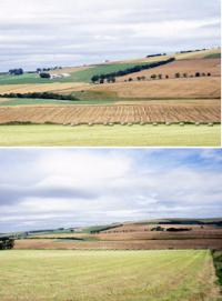
The arable grass farming here is strongly influenced by the maritime nature of the climate. The weather is variable, depending on meteorological activity in the north Atlantic Ocean. Steep gradients of temperature, oceanicity and dryness fall inland from the coast, yet extremes of heat and cold are uncommon.
The main croplands lie generally close to the coast in areas coloured red, yellow and brown in the agroclimatic map shown upper right. Long cool summers with high total solar income allow consistently high yields of the main crops. Some of the most productive farmland in Europe here lies only 50 km from arctic-alpine plateau. The croplands are not isolated, but connected to adjacent upland grazing systems by transfer of materials and the movement of plants and animals. Production has global significance through renowned products and brands.
Crops, products and impact
 Agricultural expansion, particularly since the Bronze Age, and accelerated intensification since the early 1970s, has had great effects on land cover, yield and soil. Oat, the dominant cereal in the 1800s, has now given way to barley and wheat. Not all fields have intensified equally, such that in many areas high intensity winter cropping lies close to low intensity spring cereal and sown grass. This juxtaposition, now rare in Europe, allows comparison of routes to intensification independently of climate and soil. The main crops are spring barley, winter wheat, winter barley, oat, rapeseed, potato, brassica (root and leaf), grass and soft fruit. Cereals, except oat, are mostly grown for malting, brewing and animal feed. The region is net importer of staple carbohydrate and vegetable protein.
A doubling of yield since the 1970s has not been without consequence. Intensification has impaired the functioning of the croplands' microbes, wild plants and animals, and in doing so has compromised their ability to maintain the integrity of soil and to regulate the global cycles of energy, carbon and nitrogen. Repairing essential ecological functions is imperative if agriculture is to continue at current levels of productivity.
Research and datasets

Trajectories of intensification – crop production and use of resources
Sellable output is the mainstay of these highly productive croplands: barley and wheat for malting, brewing and animal feed, oat for nutritious porridge and biscuits, rapeseed for oils, potato for mash and crisps, grass for stock, brassicas and other vegetables, soft fruit such as strawberry, blackcurrent and raspberry. Yet all these grow by the same processes – capture of energy, photosynthesis, uptake of nutrients. The study of how crops use resources to yield economic products is a major strength of the Institute.
Field experiments and mathematical models address important questions - why has yield stopped rising, how can fall in soil carbon be reversed, what constitutes sustainable cropland? Agricultural census data, backed by field records, are being used to trace the trajectories of intensification, particular through the marked rise of pesticide and fertiliser since the early 1970s. Initial work fixed on 10 areas covering the range of cropping patterns and associated inputs of fertiliser and pesticide (within the red ovals on the map of agricultural parishes, right). The work is now extending in coverage to include upland grazing land.
Contact: Graham Begg
Biodiversity – seedbanks, the arable flora, margins and food webs
The biodiversity of farmland is not a luxury, an add-on, a service to be delivered, but rather mediates all what happens to keep fields economically sound. No biodiversity – no yield! The plant species of the buried seedbank are the base of the food web. The few noxious or poisonous weeds of the flora need to be controlled, and generally are, but the majority of wild plants in farmland support invertebrates that bring benefit by controlling pests, mopping up nutrients, pollinating. Since the late 1990s, the region has been a major case study of the importance of biodiversity to farming. The Institute has the most comprehensive database on arable seedbanks in the UK, possible in Europe. Plants and invertebrates such as insects and spiders are classed into functional types and the links between types are quantified so as to understand how balance can be maintained. For example, wild plants provide habitat for parasitsoids (wasps) that in turn lay eggs in aphids that feed on crops. If the wild plants are unnecessarily killed off, the positive effects of natural biocontrol are also lost.
Contact: Cathy Hawes
Status and functioning of soil
") Soil takes hundreds to thousands of years to build. How long does it take to degrade? The qualities of agricultural soil are being measured across a range of cropping systems to see how far its properties depend on the way the land has been managed for crop production. The region is fortunate to have, side by side almost, high-intensity and low-intensity comparators that differentiated in the 1970s. The carbon content of the soil, its hardness, the ease with which roots
Soil takes hundreds to thousands of years to build. How long does it take to degrade? The qualities of agricultural soil are being measured across a range of cropping systems to see how far its properties depend on the way the land has been managed for crop production. The region is fortunate to have, side by side almost, high-intensity and low-intensity comparators that differentiated in the 1970s. The carbon content of the soil, its hardness, the ease with which roots
penetrate it, and the air and water held by soil, are all proving to be indicators of the rate at which high intensity cropping is degrading this most essential of natural capital. One question being examined is whether the falling quality of soil is now preventing further rise in yield.
Contact: Tracy Valentine
A common currency – energy and nitrogen in the ecosystem
How can the yield of a crop be valued against the losses of fertiliser to the environment or against a healthy soil or an active food web? The search for a common currency continues. The solar energy captured by crops is compared to the fossil energy in fuel. The nitrogen needed to sustain food webs is compared to the cost of nitrogen put on as fertiliser. In 2011-2012, a set of fields was sampled in detail to measure the nitrogen in soil, crops weed and inverts. The results, still under analysis, indicate that healthy food webs need only a few percent of the fertiliser, less than the nitrogen that falls from the atmosphere and much less than what’s lost to air and water. Nitrogen seems to be the currency most suitable for crossing the ecological-economic divide.
Contact: Graham Begg
Landscape measures of intensity
 Do fields ‘sense’ the landscape around them? Indicators of management intensity were estimated from government census data for fields in selected areas along the eastern maritime. Blue circles on the map to the right (upper) show localities of interest. One of these localities is magnified (lower) to show the individual fields and other parcels of land, which are distinguished by lines and colours. Statistics for fertiliser and pesticide usage, the type of crops grown and their yield were combined into an overall ‘intensity-indicator’ for each locality. Wild plant and invertebrate populations in target fields (from the 2007 survey, see below) are being looked at in relation to these intensity-measures. The postcode lottery seems to apply to plants and insects: it matters where you start in life!
Contact: Graham Begg
Gene flow and ferality – the Brassica complex
Since the middle 1990s, parts of Angus, Aberdeenshire and the Carse of Gowrie have been sites of a study of landscape-scale gene movement that is now recognised as of European significance. Pioneering work was carried out here on long-range geneflow by wind and insects, and on persistence and dispersal of seed. Notable as a unique baseline is a 500 km2 region of Angus, first surveyed in 1993 to study the Brassica complex – the interacting populations of rapeseed crops, weedy descendants, ferals growing along waysides and wild relatives.
Contact: Graham Begg
History of the 2007 and 2014 sampling campaigns
Continued work in the region was assured in 2007 through a government-funded research survey of >100 fields to establish a baseline. Soil biophysical condition, yield, agronomy and functional biodiversity in plants and invertebrates were all measured by a multidisciplinary team. The samples included the farming preferences of commercial best practice, integrated management (LEAF) and organic.
Farms were visited and samples taken by teams from James Hutton Institute (then SCRI) and SRUC (then SAC). Sites and samples became the centre of activity over the years 2007 to 2012. The James Hutton Institute made further visits and a major survey was also carried out in 2014.
All scientific measurements are subject to rigorous auditing and checking to ensure their consistency and accuracy. Data are held on a dedicated server.
A further major sampling campaign was then carried out in 2014, supported as part of the Scottish Government's 2011-2016 programme, revisiting sites surveyed seven years earlier.
Contact: Graham Begg, database manager Mark Young
Weather, climate, soil and land use
The James Hutton Institute and collaborating organisations have developed major databases of natural resources that are used as reference:
- Soil survey
- Soil point data
- Land cover
- Land Capability for Agriculture
- UK Countryside Survey
- UK National Ecosystem Assessment
Networks, links and funding
Farming and farmers
The studies would be impossible without those farmers who granted access to their land and supplied information on their yields and agronomy. We maintain a single point of contact with farmers whose confidentiality is assured. Contact: Gill Banks
The Living Field outreach project: based on the Atlantic Zone croplands but global in reach: sustainability, food production, history of farming, archaeology, art and science, plants and plant products, ecosystem services - www.livingfield.co.uk
LEAF Innovation Centre
The Mylnefield and Balruddery farms at the James Hutton Institute form a LEAF Innovation Centre. LEAF is Linking Environment and Farming, a UK-wide organisation committed to promoting environmentally sound farming. The farms are located near the centre of the region, a few miles west of Dundee.
Centre for Sustainable Cropping
The Centre for Sustainable Cropping (CSC) is a 40 hectare field platform is centred on six fields at our Balruddery Farm dedicated to a long term experiment on the evolution of sustainable cropping systems.
Glensaugh
Glensaugh, our farm near Fettercairn, is on the boundary between mixed arable and upland agriculture. Data are being collected on energy and material flows in parallel to activities at the lowland CSC near Dundee.
Funding
- Up to 2006: Government departments (SOAFD, SERAD, SEERAD and RERAD; DOE, DEFRA) and research councils.
- Scottish Government 2006-11 ‘Sustainable Production - Plants’, Workpackage 1.7 Sustainable Crop Systems (James Hutton Institute and SRUC).
- Scottish Government 2011-16, Strategic Research Programmes: Ecosystem Services Theme and Land Use Theme (James Hutton Institute).
- Scottish Government funding continues within new programmes after 2016.
- EU projects including SIGMEA, Legume Futures (new legume cropping systems), AMIGA (environmental risk assessment) and PURE (integrated pest management).
This update: 27 March 2017
Images on this page, top to bottom: map from Assessment of climatic conditions in Scotland by E L Birse and colleagues (1970), The Macaulay Institute for Soil Research (now The James Hutton Institute); photographs of Aberdeenshire cropland (G R Squire); map of Scotland's parishes used in the annual agricultural census with red ovals showing targets of study; images of barley (upper) ear of a six-row variety, (mid and lower) field of a spring variety (G R Squire); map showing around 50 target locations for study of landscape intensity, and (lower) map of individual fields and other land parcels in a 2-km radius around one of fifty sites (G S Begg).
