Hutton awarded £40,000 to create interactive digital models of Scotland’s landscapes using Immersive Suite
Researchers at The James Hutton Institute, Scotland’s pre‑eminent interdisciplinary research institute for sustainable land, crop and nature management, have been awarded £40,000 by the Macaulay Development Trust to create interactive 3D representations of Scottish landscapes using cutting-edge data and immersive technology.
The project, titled ‘3D GIS and GeoAI for coherent, scalable interactive landscapes’, will explore how the nation’s terrain can be better understood, visualised and discussed through interactive 3D mapping.
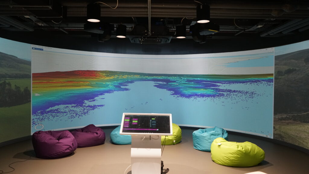
To create the virtual landscapes, researchers will use data from the Scottish Government’s new Scotland-wide LiDAR programme. This groundbreaking initiative captures landscapes in centimetre-level resolution by using aircraft-mounted lasers to fire pulses down to the ground. These pulses are then reflected back up, and the time taken for the pulse to return to the aircraft is used to calculate the distance to the ground below.
Using this detailed data, Hutton researchers will be able to create engaging visuals that can support discussions about land management for climate, biodiversity, food production, communities and the economy. These visuals will be displayed at the new Immersive Suite at the Hutton’s Craigiebuckler campus. This state-of-the-art facility – which was funded by the Scottish Government’s Just Transition Fund, the Macaulay Development Trust and the UK Department for Science, Innovation and Technology – is equipped with a media server, games engine, surround sound and nine projectors, allowing simulated landscapes to be projected across the suite’s walls for a fully immersive experience.
This project, which is due to begin in October and last one year, will support Scotland’s ambitions around net-zero, nature recovery, climate adaptation and fair land-use transitions. It will also showcase the value the national LiDAR mapping programme and provide a new way for people to engage with the data it generates.
Dr Chen Wang, a research scientist on landscape visualisation at the Hutton, said, “The work will create new opportunities for dialogue across policy, research, land management, and community audiences, helping to support more inclusive planning for Scotland’s future landscapes.”