ILUSC: Models on Land Use
The James Hutton Institute has developed a range of datasets and tools that build understanding of land use, landscapes and land use change. Here is a selection of tools and methods already developed that can help to build understanding of landscapes and land uses. Many of these have been developed for the Scottish context but are adaptable elsewhere.
Landsfacts
This model shows spatial land use change scenarios under climate change. Its latest developments include shaping the land use changes to enhance multiple Ecosystem Services, while considering land capability and farm types.
https://ics.hutton.ac.uk/landsfacts/

TRACCE (Trees and Climate ChangE)
This app lets you explore how climate might shape where native trees can thrive across the UK, exploring the effect of different climate change scenarios.
https://abshy02.hutton.ac.uk/tracce

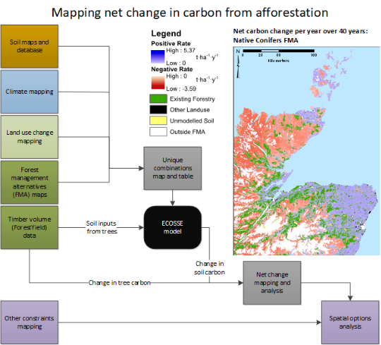
Woodland expansion
This online mapping tool visualises net change in carbon (combining soils and vegetation) from afforestation over time for different woodland planting options.
Mapping Net Change in Carbon from Afforestation in Scotland
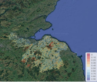
EcoForest (ECOsystem services and reFORESTation)
EcoForest is a web-based interactive tool that allows non-experts to suggest suitable areas for plating of new woodlands via spatial multi-criteria analysis. It is based on maps that show where different benefits from afforestation could occur: users select the benefits and their importance; individual maps are combined to give a map of overall planting priorities.
Other models
RIVERTOOL (Riparian Vegetation Ecosystem Services-based Ranking Tool) is the “riparian-only” version of ECOFOREST (with some extra relevant data).
FARMTREE landscape tool. Spatial multicriteria analysis to site agro-forestry.
For more information on many of the researchers and research that produce these, and other tools, please visit https://ics.hutton.ac.uk/research/land-systems-research-team/ You can also visit https://www.hutton.ac.uk/soil-data-and-maps/ to find out more about soils data and maps, which underlie many of these models.